Geography
Ancient Megara was located in the northern part of the Isthmus of Cornith, along the shoreline at 38 degrees north and 23 degrees, 20 minutes east, almost the same longitude as Cupertino, California (off by less then 1 degree north), and is isolated to the northwest by a high mountain range. Its shoreline location, however, allowed it to develop into a major trading port that exported products such as flour, wool, and olive oil. Megara also exported beautiful textiles, for which it was famed. Megara is located in the Attica (sometimes spelled Attika) region, centered mostly on the Attic peninsula.
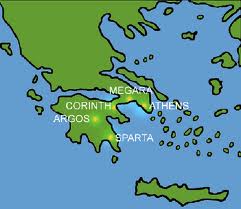
As seen in the picture, Megara was located relatively close to both Corinth and Athens. In its early history, Megara was actually a dependency of Corinth (read more in the History of Megara section).
Modern Megara
The ancient Attica region was slightly smaller in area then its modern counterpart, which includes several islands and extends into the Peloponnese area. Modern Megara is an urban area, with a population of almost 37,000 people (as of 2011) and an area of 124 square miles (as of 2011), with a population density of 230 people per square mile (2011). It is linked to Athens, 42 miles northwest, by a highway which also links it to the Peloponnese.
